
Waterfowl Aerial Inventories
The Illinois and Mississippi river valleys are major migration and wintering areas for nearly 30 species of waterfowl in the Mississippi Flyway. The INHS, with support from the IDNR and the Federal Aid to Wildlife Restoration Fund through the U.S. Fish and Wildlife Service (USFWS), has conducted aerial inventories of waterfowl along the Illinois and Mississippi rivers since 1948 (flown each year but 2001). This undertaking represents the longest known inventory of waterfowl, preceding even the USFWS breeding waterfowl counts and mid-winter inventories established in 1955. Therefore, 65 years of data exist on fall-migrating waterfowl for these critical ecoregions and has vastly improved our understanding of the chronology of migration, the effects of refuges, and the distribution of waterfowl in Illinois. Data from this project was published in 1999: Havera, S.P. 1999. Waterfowl of Illinois: Status and Management (and Abbreviated Field Guide): INHS Special Publication 21 and INHS Manual 7. Ill. Nat. Hist. Surv. Rep. No. 358:5, 7.

Evaluation of an Aerial “Grid” Waterfowl Survey along the Illinois River
Traditional aerial surveys conducted along the Illinois and Mississippi Rivers provide an index of population size rather than an actual population size. New methods may allow researchers to determine actual population sizes within our survey area along with estimates of variance. However, changing to a new methodology may have implications for the use of 65 previous years’ worth of index counts. Thus, we are conducting a new “grid” survey following each traditional survey to ensure that we maintain a relationship between the new estimates and those from previous years. Each week, we will conduct aerial surveys of approximately sixty 1-sq mi “grids” within the Illinois River floodplain from Hennepin to Meredosia, IL. These grids will be randomly placed within the study area and will include portions of traditional “core” survey locations (e.g., Chautauqua NWR, Rice Lake, Meredosia NWR, etc.) and other “random” survey locations (e.g., drainage and levee districts, Anderson Lake, Pekin Lake, etc.). The aerial grid surveys will be flown each week following the traditional inventory-style aerial survey. Click here for more information.

Waterfowl & Wetland Habitat Monitoring at the Emiquon Preserve
Emiquon Preserve, a 7,000 acre drainage and levee district adjacent to the Illinois River near Havana, IL was acquired by The Nature Conservancy in 2000. This property, home to Thompson and Flag Lakes, was known as 2 of the most productive lakes in the Illinois River valley. Drained and used for agricultural production for approximately 70 years, The Nature Conservancy has since restored the historic lake basins. As water and wildlife return to the property, we will monitor waterbird use and changes in habitat characteristics. To accomplish this, we’ve conducted ground and aerial surveys of waterfowl and other waterbirds during spring and fall migrations, summer brood monitoring, aquatic invertebrate monitoring during brood rearing, annual evaluation of moist-soil plant seed production in fall, and wetland habitat mapping to document annual changes in habitat quality and diversity as the site develops. Monitoring began in fall 2007, and waterfowl have responded favorably to the restoration. Peak fall abundance has topped 90,000 waterfowl and peak spring abundance has exceeded 119,000 comprised of 20 duck, 3 goose, and 3 swan species. Additionally, 23 species of non-waterfowl avifauna have been observed at the preserve. Habitat monitoring and mapping has revealed significant growth in wetland area at the Emiquon Preserve from 630 acres in 2007 to a peak of 4,747 wetland acres in 2010.

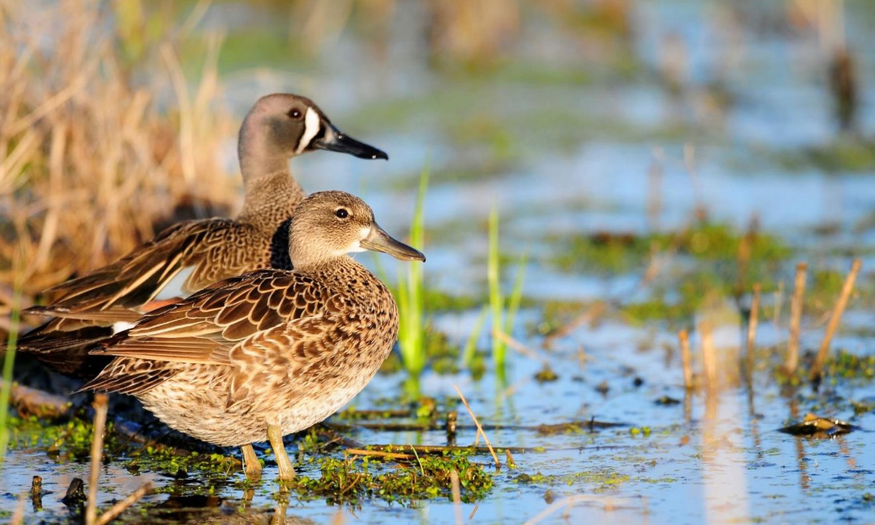
Ecology of Spring-migrating Canvasbacks and Lesser Scaup in the Central Illinois and Mississippi River Valleys
Habitat quality for diving ducks during spring migration may affect body condition and reproduction during the breeding season. Recent evidence suggests wetlands associated with the Illinois and Mississippi River Valleys, historically important stopover habitats, provide limited seed and invertebrate biomass for waterfowl. Substantial use of this region by spring-migrating lesser scaup (Aythya affinis) and canvasbacks (A. valisineria) warrants assessing the quality of these wetlands as foraging habitats and comparing results with other body condition and food availability studies in the Upper Midwest. We located and surveyed flocks of lesser scaup and canvasbacks during spring 2014 and experimentally collected individuals to evaluate body condition, contaminant loads, food use and selection, and parasite loads. Further, we collected blood samples for metabolite analysis to determine if birds were building lipid reserves and fecal corticosterone samples to monitor stress levels. Comparison of these results with concurrent food availability estimates will help determine if current indicators of habitat quality (i.e. biomass of food items) are actually related to condition and subsequent fitness of individual foragers.

Body Composition, Intestinal Parasite Loads, and Blood Parameters of Spring-migrating Lesser Scaup in the Upper Midwest
Conner England is a Graduate Research Assistant for the INHS and is attending the University of Illinois at Urbana-Champaign. He has a B.S. in Wildlife and Fishery Science from the University of Tennessee. His current research focuses on the body condition, blood parameters, and effects of intestinal parasite loads on the health of spring-migrating lesser scaup and canvasbacks. Infections by parasitic trematodes appear to be having an increasingly important impact on the health of wildlife populations. Recently, infections of the trematodes (Cyathocotyle bushiensis and Sphaeridiotrema globulus) through ingestion of the second intermediate host, the faucet snail (Bithynia tentaculata), have caused mortality of lesser scaup in the upper Midwest. These parasites, in conjunction with declines in diving duck foraging habitat, are believed to be a key factor in the recent declines in lesser scaup populations. The goals of Conner’s research are to determine sub-lethal trematode loads, examine duck body composition and blood parameters, and compare these findings with other metrics of duck health and wetland condition for lesser scaup and canvasbacks.

Greater Chicago Metropolitan Area Canada Goose Project
Canada geese (Branta canadensis) are important both ecologically and economically throughout Illinois and the Midwest. There are two populations of Canada geese that seem to congregate in the Greater Chicago Metropolitan Area (GCMA), temperate-breeding Canada geese which are often called “resident geese” and subarctic-breeding Canada geese which breed on the southern portions of Hudson Bay and migrate to Wisconsin and Illinois during December and January. Recent anecdotal information suggests that the subarctic-breeding population is wintering farther north than where they have historically. With temperate-breeding populations increasing and subarctic-breeding Canada geese wintering in more northerly areas, there has been a dramatic increase in Canada goose populations in the GCMA. Larger Canada goose populations increase the potential conflicts with humans, especially nearby airports such as Midway International Airport (MIA). During winter, large groups of geese congregate on the Chicago sanitary and ship canal and the Des Plaines River and pose serious threats to air traffic during landing and takeoffs at MIA. We will leg-band and neck-collar several thousand resident and migrating Canada geese during winters 2014-2016 and track movements using GSM cellular tracking devices to better understand what influences winter movements of these birds.

An Assessment of Aquatic Invasive Plants in the Illinois River: Water Hyacinth Surveillance, Mapping, Persistence, and Potential Seed Dispersal
Jay VonBank is a Graduate Research Assistant for the INHS and is attending Western Illinois University. He has a B.S. in Aquatic Biology-Fisheries from Bemidji State University. His current research focuses on invasive water hyacinth in the upper Illinois River/Chicago Area Waterway System (CAWS). Water hyacinth forms dense mats of vegetation on the surface of slow-moving waterways and backwaters restricting commercial and recreation traffic, outcompeting native vegetation and affecting natural biogeochemical and evapotranspiration cycles. Regular reoccurrence of water hyacinth represents a significant threat to the recreation, fisheries, and wildlife resources of both the Great Lakes and the Illinois & Mississippi River basins. The goals of Jay’s research are to document the current distribution of water hyacinth, compare water hyacinth seed densities and frequencies in the seed bank, assess Common Carp and Grass Carp diets to determine water hyacinth seed dispersal potential, and to develop an aerial survey technique for the surveillance of water hyacinth.

Breeding Bird Use of Wetlands Managed for Waterfowl in Illinois
Kristen Walter is a Graduate Research Assistant for the INHS, and is attending the University of Illinois at Urbana-Champaign. She has a B.S. in Biology from Central Michigan University, and has done avian field work in California, Oregon, Michigan, and Illinois. Her current research is focusing on the way grassland birds use moist-soil wetland habitat that is managed for waterfowl. Many guilds of breeding birds are declining in population, and grassland birds are no exception. A key assumption of several conservation planning documents is that some non-wetland bird habitat and population objectives can be accomplished by fulfilling waterfowl habitat objectives. Quantifying the benefits of moist-soil vegetation managed for waterfowl to other wildlife, specifically other birds, will help guide development of IDNR land management strategies and the Illinois Wetlands Campaign documents.

Ecology of Fall-migrating Mallards in the Illinois River Valley
We investigated migration ecology of mallards utilizing the Illinois River corridor during fall 2009–2010. We radiomarked 142 mallards (86 females, 56 males) along LaGrange Pool of the Illinois River with backpack transmitters during autumn. We estimated a minimum daily movement distance of 3.9 ± 0.2 km among wetlands. Females flew 2.6 ± 0.2 km to evening foraging areas. Mallards utilized many wetland basins during their stay and home range size was 17,575 ± 1,506 ha. We located mallards on wetlands available for hunting (i.e., not designated as refuge) for the majority (79.6%) of diurnal locations. Forty-four of 142 (31 %) radio-marked mallards perished during their stopover period in LaGrange Pool, and 77% of mortality was directly due to hunting. Correspondingly, males and females were observed on refuges only 20.4% and 20.3% of their daytime locations, respectively. Results from this study were published in 2014: Hagy HM, Yetter AP, Stodola KW, Horath MM, Hine CS, Ward MP, Benson TJ, Smith RV, Stafford JD. 2014. Stopover duration of mallards during autumn in the Illinois River valley. The Journal of Wildlife Management 78(4):747–752; 2014; DOI: 10.1002/jwmg.708.

Foraging Ecology of Fall Migrating Shorebirds in the Illinois River Valley
Populations of many shorebird species appear to be declining in North America. Causes of the declines are not fully understood but because shorebirds migrate very long distances each year, availability of food may be important to survival and reproduction. The Illinois River valley contains critical habitats where shorebirds stop during migration. In fact, Chautauqua National Wildlife Refuge was designated a World Hemisphere Shorebird Reserve Network site and may host 100,000-250,000 shorebirds during fall. Despite the importance of the region, little is known about the ecology of foraging shorebirds in Illinois. To address this research need, we collected 4 species of shorebirds (Pectoral and Least Sandpipers, Lesser Yellowlegs, and Killdeer) during falls 2007 and 2008 to identify foods they ate and evaluated their body condition. Additionally, we took core samples from wetlands to identify abundance of invertebrates that shorebirds may have consumed. Results from this study were published in 2012: Smith RV, Stafford JD, Yetter AP, Horath MM, Hine CS, et al. (2012) Foraging Ecology of Fall-Migrating Shorebirds in the Illinois River Valley. PLoS ONE 7(9): e45121. doi:10.1371/journal.pone.0045121

Estimation of Moist-soil Plant Seed Abundance for Waterfowl on Public Lands in Illinois
Moist-soil management is employed throughout the U.S. to provide managed habitats for waterfowl and other waterbirds that are rich in food resources. Because much of Illinois contains critical habitat for migrating waterfowl, moist-soil management is a common waterfowl management practice in the state. Many IDNR sites practice moist-soil management, yet their combined contribution to foraging carrying capacity for waterfowl is not known. This study was designed to estimate moist-soil plant seed abundance and generally evaluate quality of moist-soil habitats on public lands in Illinois. Results from this study were published in 2011: Stafford JD, Yetter AP, Hine CS, Smith RV, Horath MM. 2011. Seed abundance for waterfowl in wetlands managed by the Illinois Department of Natural Resources. Journal of Fish and Wildlife Management 2(1):3–11; e1944-687X. doi: 10.3996/092010-JFWM-034

Historical and Contemporary Characteristics of Illinois River Valley Wetlands: A Geospatial Database for Conservation Planning and Evaluation
In recent years, numerous restoration projects have been initiated in the Illinois River floodplain. Information on historical conditions of floodplain wetlands and investigations of change in conditions over time would provide valuable information to guide the restoration and planning process. To address these information needs, we created a geospatial database of historical wetland conditions in the Illinois River valley from maps created by Dr. Frank C. Bellrose and INHS staff during 1939-1959 and re-mapped 15 of these wetlands using modern techniques during 2005-2006. We analyzed these data to identify changes in wetland conditions over time and factors influencing use of IRV wetlands by mallards and diving ducks based on aerial inventories. Results from this study were published in 2010: Stafford, J. D., M. M. Horath, A. P. Yetter, R. V. Smith, and C. S. Hine. 2010. Historical and contemporary characteristics and waterfowl use of Illinois River valley wetlands. Wetlands (2010) 30:565-576.